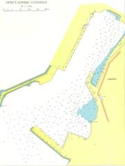
port map 1
800 x 1079 px
size 133 Kbytes
port map 2
3388 x 4560 px
size 942 Kbytes
|
GPS position of main breakwater: N 42° 25. 25': E 27° 41. 0'
Dangers in approach: N 42° 25. 2': E 27° 41. 5'
VHF channels :Fixed fish traps and nets NW of island Sv.Ivan
VHF channels :Harbourmaster VHF 16 and 11.
Shelter: Good
Charges: 5 leva/day, security tax in 'marina'.
| Electricity | no |
|---|
| Whater | no |
|---|
| Fuel | no |
|---|
| Repairs | no |
|---|
|