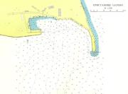
port map 1
799 x 591 px
size 39 Kbytes
port map 2
2029 x 1500 px
size 215 Kbytes
|
GPS position of main breakwater: N 42° 10. 15' : E 27° 51. 6'
Dangers in approach: Rocks southeast of harbour N 42°10.10' : E 27°52.05' marked by lit beacon. These are not shown on any chart.
VHF channels: VHF 16
Shelter: Good
Formalities: Border Police visit yacht on arrival.
Цени:
| Electricity | On quay. |
|---|
| Water | On quay. |
|---|
| Fuel | no |
|---|
| Repairs | Mechanical and polyester. In the vicinity of Tzarevo is a factory "PASAT" producing GRP products and large GRP catamarans |
|---|
|