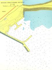
port map 1
800 x 1074 px
size 82 Kbytes
port map 2
1500 x 2014 px
size 328 Kbytes
|
GPS position of main breakwater: N 42° 39. 2' :E 27° 43. 7'
Dangers in approach:
Extensive rocks lying east of Nesebar.The Red Buoy in the harbour had no navigation significance for yachts- it marks the intended extent of the marina. If entering the marina stay within 10m of the end of the marina northeast mole to avoid the rock in the bay which forms part of the marina.
VHF channels : Port Control VHP 1 6 and VHP 1 1 .
Shelter : Good, Yacht Club better.
Formalities: Customs and Border Police will visit on arrival.
Charges : 1.5 leva/metre/day.
| Electricity | Yes |
|---|
| Water | Tap at Yacht Club. |
|---|
| Fuel | no |
|---|
| Repairs | no |
|---|
|

 Login
Login your pictures