Coast Guide Coast Guide |
|---|
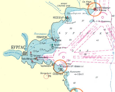
Coast Guide for Bulgarian Coast from Cape Korakia to Cape Emine
|
The South coast of Burgas Gulf is rocky, high and highly devoured by many capes and small gulfs. Big sand beaches aper on some places. The overall direction of the coast is Nort - West to Cape Akin, and West to Burgas.
Many riffs abear in front of the capes and islands, but not far than 0.3 n miles from the coast. One mile from the coast there are no navigation dangers.
Most important are Cape Agalina, Cape Kolokita, Kiril Peninsula, Cape Atia Cape Chukalia and Cape Foros.
Small ships can anchor in Port Sozopol, Port Atia, Port Druzba and Port Burgas and in the gulf of the Ropotamo River outfall, under Cape Kolokita and behind Cape Akin.
Dangerous for the small ships are:
Rock riff, deep 7.2m starts 2 n miles North-West of Cape Kilokita and lays 1.7 n miles North-West. It's wide 0.1 n miles.
0.1 n miles East of Cape Hrisosotira there is riff.
From the South-West end of St. Ivan Island, 2.5 n miles South-West the coast there is reef deep 5.1m.
Cape Talaskara is surrounded by reef, laying 0.1 n miles in the sea.
Malatzite Rocks are 0.15 n miles North-East of Cape Akin.
0.85 n miles South-East of there is rock bank 0.3 n miles from the coast, deep 0.9m.
0.2 n miles North of Cape Atia there is reef, deep less thjan 10m.
St Anastasia Island is surrounded by reef, which protrudes 0.15 n miles on the South. In the edn the reef is deep 5m.
There is magnetic anomaly. Between the island and Cape Chukalia the anomaly is between 2deg. 8min. and 16deg. 8min. and North of the island upto +5degrees.
In front of Cape Foros there are underwater rocks.
From Burgas to Cape Emine the North coast of Burgas Gulf is mostly low and flat. It's high only from St. Vlas to Cape Emine. There are two big peninsulas - Pomorie and Nesebar.
The north part of the gulf is much more shallow than the south, there are many shoals, banks and riffs.
Important places are towns of Pomorie, Nesebar and cape Emine.
Except in ports of Burgas, Pomorie and Nesebar small ships can anchor under Cape Akrotiria, southwest of Cape Ravda, in th nort and south gulfs of Nesebar and under Cape Emine.
Riff, deep 2m spreeds 1.2 n miles south of Cape Lahna. It's wide about 1 mile.
Between Burgas and Cape Lahna there is shoal, deep 10 to 2 meters, called Sokat. There are many rocks 2 miles along the riff.
Southwest of Cape Lahna there is bank, deep 4.3m.
Blond Bank is 2.5 n miles east of cape Lahna. It's deep 7.6m
Spitfire bank is 2.3 n miles south of cape Lahna and is deep 5.4 meters.
Stavrova Bank, deep 4.6m, is 2.4 n miles south of Pomorie Peninsula.
Shoal deep 8m lays 0.6 n miles south of Pomorie lighthouse.
Pomorie riff is deep 3 to 9 meters and starts from the southeast end of Cape Pomorie and lays 0.8 n miles northeast in the sea. In the southeast end of the rif is the Pomorie Lighthouse.
Chimovo Bank is deep 6.4m and starts 1.5 n miles north of the east end of Pomotie Peninsula and lays 1.5 n miles north along the coast.
Ravda riff is deep 5.2m and lays 0.8 n miles south of Cape Ravda.
0.5 n miles southeast of Cape Akrotiria there is riff deep less than 10m, on some places there are rocks ovber the water.
All the Nesebar Peninsula is surrounded by rocks. To avoid them one must approach between 60 and 150 degrees.
|
| Name
| φ
| λ
| Parameters
| Description
|
| Agalina Navigation Mark |
42° 23' N |
27° 43' E |
|
Steel construction with black and white horizontal stripes. Hight above the water - 103m. |
| St. Ivan Lighthouse |
42° 26' N |
27° 72' Å |
Á Ïð 10 c 18 n.mile |
White round tower with house beside it. Hight above the water - 44m. |
| Szopol navigation mark |
42° 25' N |
27° 41' E |
|
Steel construction with black and white horizontal stripes. Hight above the water - 70m. |
Port Sozopol
West navigation mark |
|
|
×â Èçî 4 ñ 1 n.mile |
Grey steel pole. Lights in sector 110 - 242. hight above the water 6m. |
| East navigation mark |
|
|
Çë Èçî 4 ñ 1 n.mile |
Grey steel pole. Lights in sector 209 - 90 |
| The Blinker |
42° 25' N |
27° 41' Å |
Á × (9) 15 ñ 2 n.mile |
White tower with steel construction on the top, high 9m. |
| Budjaka navigation mark |
42° 27' N |
27° 35' Å |
|
Steel construction with black and white horizontal stripes. Hight above the water - 117m. |
Port Atia
South navigation mark |
|
|
Çë Ïð 2 ñ 2 n.mile |
Green concrete pole, high 10m. |
| North navigation mark |
|
|
×â Ïð 2 ñ 2 n.mile |
Red concrete poli, high 11m. |
| Bouy - special mark |
42° 29' N |
27° 42' E |
Æ Ïð 5 ñ 2 ï.mile |
Yellow bouy with yellow cross on the top. |
| Axis bouy |
42° 29' N |
27° 38' E |
Á Èçî 6 ñ 2 n.mile |
Bouy with black and red vertical stripes with red sphera on top. |
| Axis bouy |
42° 29' N |
27° 35' Å |
Á Èçî 6 ñ 2 n.mile |
Bouy with black and red vertical stripes with red sphera on top. |
| Bouy - special mark |
42° 28' N |
27° 33' Å |
Æ Ïð 5 ñ 2 n.mile |
Yellow bouy with yellow cross on the top. |
| St. Anastasia Lighthouse |
42° 28' N |
27° 33' E |
Á ×â Ïð 8 ñ 15/8 n.mile |
White concrete tower, lights in sectors: 132 - 92 - white, 92 - 132 - red. |
| Druzba |
42° 27' N |
27° 32' Å |
×â Ïð 20 ñ 5 n.mile |
White concrete platform |
| Burgas lighthouse |
42° 29' N |
27° 29' Å |
Á Ïð 3 ñ 10 n.mile |
White steel tower. Light in sector 73 - 333. |
| South bouy |
42° 29' N |
27° 31' Å |
Á× (6) Äë Ïð 15 ñ |
Pole bouy, upper part yellow, down part - red. Figure - two cones with tops each to each. |
| Stavrova Bank - east bouy |
42° 31' N |
27° 39' Å |
Á× (3) 10 ñ |
Red bouy with wide horizontal yellow stripe. |
| Pomorie light mark |
42° 33' N |
27° 40' Å |
Á× (3) 10 ñ 6 n.mile |
White rock tower |
| Nesebar navigation mark |
42° 39' N |
27° 44' Å |
Çë ×â Ïð 8 ñ 2/4 n.mile |
Steel construction, lights in sectors: red - 60 - 105, green - 105 - 60. Hight above the water - 9.5m |
| Emine lighthouse |
42° 42' N |
27° 54' Å |
Á Ïð 6 ñ 20 n.mile |
White tower iwth building beside her. Radiomayak. Hight - 64m. |
|
|

 your pictures